TDRSS scaled map for 1014316
GCN BAT Position Notice
TITLE:           GCN/SWIFT NOTICE
NOTICE_DATE:     Wed 23 Dec 20 17:58:41 UT
NOTICE_TYPE:     Swift-BAT GRB Position
TRIGGER_NUM:     1014316,   Seg_Num: 0
GRB_RA:          132.849d {+08h 51m 24s} (J2000),
                 133.367d {+08h 53m 28s} (current),
                 131.600d {+08h 46m 24s} (1950)
GRB_DEC:         +71.174d {+71d 10' 26"} (J2000),
                 +71.094d {+71d 05' 38"} (current),
                 +71.361d {+71d 21' 39"} (1950)
GRB_ERROR:       3.00 [arcmin radius, statistical only]
GRB_INTEN:       2902 [cnts]    Image_Peak=162 [image_cnts]
TRIGGER_DUR:     1.024 [sec]
TRIGGER_INDEX:   146     E_range: 25-100 keV
BKG_INTEN:       16813 [cnts]
BKG_TIME:        64693.79 SOD {17:58:13.79} UT
BKG_DUR:         8 [sec]
GRB_DATE:        19206 TJD;   358 DOY;   20/12/23
GRB_TIME:        64706.97 SOD {17:58:26.97} UT
GRB_PHI:          91.75 [deg]
GRB_THETA:        25.08 [deg]
SOLN_STATUS:     0x3
RATE_SIGNIF:     15.19 [sigma]
IMAGE_SIGNIF:    8.13 [sigma]
MERIT_PARAMS:     +1  +0  +0  +0  +2  -2  +0  +0 +60  +0
SUN_POSTN:       272.59d {+18h 10m 22s}  -23.41d {-23d 24' 51"}
SUN_DIST:        126.95 [deg]   Sun_angle= 9.3 [hr] (West of Sun)
MOON_POSTN:       21.77d {+01h 27m 05s}   +4.26d {+04d 15' 22"}
MOON_DIST:        92.79 [deg]
MOON_ILLUM:      67 [%]
GAL_COORDS:      142.91, 35.11 [deg] galactic lon,lat of the burst (or transient)
ECL_COORDS:      110.29, 50.74 [deg] ecliptic lon,lat of the burst (or transient)
COMMENTS:        SWIFT-BAT GRB Coordinates.
COMMENTS:        This is a rate trigger.
COMMENTS:        A point_source was found.
COMMENTS:        This does not match any source in the on-board catalog.
COMMENTS:        This does not match any source in the ground catalog.
COMMENTS:        This is a GRB.
COMMENTS:        This trigger occurred at longitude,latitude = 182.20,15.00 [deg].
GCN BAT Scaled Map Notice
TITLE:           GCN/SWIFT NOTICE
NOTICE_DATE:     Wed 23 Dec 20 18:09:13 UT
NOTICE_TYPE:     Swift-BAT Scaled Map
TRIGGER_NUM:     1014316,   Seg_Num: 0
POINT_RA:        221.793d {+14h 47m 10s} (J2000)
POINT_DEC:       +72.754d {+72d 45' 13"} (J2000)
MAP_DATE:        19206 TJD;   358 DOY;   20/12/23
MAP_TIME:        64706.97 SOD {17:58:26.97} UT
TRIGGER_DUR:     1.024 [sec]
SOLN_STATUS:     0x3
RATE_SIGNIF:     15.19 [sigma]
IMAGE_SIGNIF:    8.13 [sigma]
MAP_URL:         sw01014316000msbsm.fits
SUN_POSTN:       272.60d {+18h 10m 24s}  -23.41d {-23d 24' 51"}
MOON_POSTN:       21.85d {+01h 27m 23s}   +4.29d {+04d 17' 31"}
MOON_ILLUM:      67 [%]
GAL_COORDS:      111.84, 41.79 [deg] galactic lon,lat of the pointing direction
ECL_COORDS:      138.06, 72.71 [deg] ecliptic lon,lat of the pointing direction
COMMENTS:        SWIFT-BAT Scaled Map.
COMMENTS:
COMMENTS:        The next comments were copied from the BAT_POS Notice:
Scaled map image
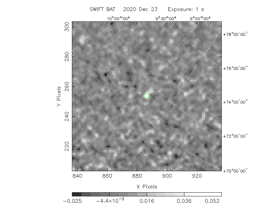
The green circle (6 arcmin radius) is the BAT position (RA, Dec) = (132.849, +71.174).
Search BAT source with the INTEGRAL catalog
known_source_INTEGRAL.sh 132.849 +71.174 1.0
QSOB0836+710    ( 130.352 ,  70.895 )     delta= 0.858
Results of batcelldetect
# RAcent  DECcent POSerr Theta    Phi  PeakCts   SNR AngSep     Name
#  [deg]    [deg]    ['] [deg]  [deg]                   [']
  7.2036  59.2894    0.0  45.9  165.1   0.0151   1.5    0.0	V709 Cas
 19.5112  65.2916    0.0  41.2  155.2   0.0076   0.9    0.0	4U 0114+65
 93.9015  71.0375    0.0  32.4  112.7   0.0004   0.0    0.0	Mkn 3
166.6979  72.5686    0.0  15.8   77.2   0.0022   0.4    0.0	NGC 3516
169.5454  48.0369    0.0  33.7   33.4  -0.0013  -0.2    0.0	XTE J1118+480
182.6357  39.4057    0.0  38.4   13.1  -0.0013  -0.2    0.0	NGC 4151
254.4576  35.3425    0.0  40.9  -81.0   0.0053   0.2    0.0	Her X-1
299.8682  40.7339    0.0  48.0 -132.1  -0.0030  -0.1    0.0	Cyg A
308.0633  37.6375    0.0  53.2 -138.2   0.0025   0.1    0.0	EXO 2030+375
308.1103  40.9526    0.0  50.2 -139.8  -0.0193  -1.0    0.0	Cyg X-3
314.6979  41.7770    0.0  51.3 -146.1   0.0154   0.9    0.0	GRO J2058+42
321.1638  50.9739    0.0  44.7 -156.6   0.0069   0.9    0.0	IGR J21247+5058
323.4320  51.1236    0.0  45.1 -158.5   0.0125   1.5    0.0	RX J2133.7+5107
326.1717  38.3217    0.0  57.7 -154.7  -0.0414  -1.4    0.0	Cyg X-2
331.9808  54.5197    0.0  44.1 -167.2   0.0014   0.2    0.0	4U 2206+54
350.9671  42.1830    0.0  59.8 -177.1   0.0034   0.1    0.0	1ES 2321+419
132.8924  71.1802    1.4  25.1   91.7   0.0608   8.4 ------	UNKNOWN
149.8775  63.2136    3.0  26.6   68.3   0.0273   3.9 ------	UNKNOWN
198.6202  42.5563    2.3  32.1   -5.7   0.0278   5.0 ------	UNKNOWN
Search for the BAT bright source catalog
# RAcent  DECcent POSerr Theta    Phi  PeakCts   SNR AngSep     Name
#  [deg]    [deg]    ['] [deg]  [deg]                   [']
254.4576  35.3425    0.0  40.9  -81.0   0.0053   0.2    0.0	Her X-1
308.1103  40.9526    0.0  50.2 -139.8  -0.0193  -1.0    0.0	Cyg X-3
326.1717  38.3217    0.0  57.7 -154.7  -0.0414  -1.4    0.0	Cyg X-2
132.8924  71.1802    1.4  25.1   91.7   0.0608   8.4 ------	UNKNOWN
149.8775  63.2136    3.0  26.6   68.3   0.0273   3.9 ------	UNKNOWN
198.6202  42.5563    2.3  32.1   -5.7   0.0278   5.0 ------	UNKNOWN

Search for UNKNOWN source R.A. = 132.8924 Dec. = +71.1802 (search radius of 3 degrees)
No bright source found.

Search for UNKNOWN source R.A. = 149.8775 Dec. = +63.2136 (search radius of 3 degrees)
No bright source found.

Search for UNKNOWN source R.A. = 198.6202 Dec. = +42.5563 (search radius of 3 degrees)
No bright source found.
DPI of the combined detector enable/disable map (archived enable/disable map + downloaded data)

DPI of the scaled map

Pixel vs. Counts plot

The data/results are in /local/data/bat1/prebascript/trigger1014316/tdrss_ql/

bat_scaledmap.fits : TDRSS FITS scaled map from GCN
source.img         : Sky FITS image of the scaled map (batfftimage)
source.list        : FITS list of the detected sources (batcelldetect)
scaledmap.log      : Ascii output of the analysis log
bat_pos.reg        : region file for ds9
source.gif         : GIF sky image

Processed time:
Wed Dec 23 13:10:19 EST 2020