TDRSS scaled map for 176918
GCN BAT Position Notice
TITLE:           GCN/SWIFT NOTICE
NOTICE_DATE:     Wed 11 Jan 06 20:16:03 UT
NOTICE_TYPE:     Swift-BAT GRB Position
TRIGGER_NUM:     176918,   Seg_Num: 0
GRB_RA:          286.337d {+19h 05m 21s} (J2000),
                 286.324d {+19h 05m 18s} (current),
                 286.443d {+19h 05m 46s} (1950)
GRB_DEC:         +70.360d {+70d 21' 35"} (J2000),
                 +70.369d {+70d 22' 09"} (current),
                 +70.281d {+70d 16' 52"} (1950)
GRB_ERROR:       3.00 [arcmin radius, statistical only]
GRB_INTEN:       4603 [cnts]    Image_Peak=145 [image_cnts]
TRIGGER_DUR:     1.024 [sec]
TRIGGER_INDEX:   155     E_range: 50-350 keV
BKG_INTEN:       26910 [cnts]
BKG_TIME:        72927.05 SOD {20:15:27.05} UT
BKG_DUR:         8 [sec]
GRB_DATE:        13746 TJD;    11 DOY;   06/01/11
GRB_TIME:        72943.24 SOD {20:15:43.24} UT
GRB_PHI:         113.46 [deg]
GRB_THETA:        33.22 [deg]
SOLN_STATUS:     0x83
RATE_SIGNIF:     18.52 [sigma]
IMAGE_SIGNIF:    6.97 [sigma]
MERIT_PARAMS:     +1  +0  +0  +0  +3  +6  +0  +0  +3  +1
SUN_POSTN:       293.21d {+19h 32m 49s}  -21.72d {-21d 43' 29"}
SUN_DIST:         92.22 [deg]
MOON_POSTN:       81.33d {+05h 25m 19s}  +28.07d {+28d 04' 16"}
MOON_DIST:        79.95 [deg]
MOON_ILLUM:      94 [%]
GAL_COORDS:      101.34, 24.29 [deg] galactic lon,lat of the burst (or transient)
ECL_COORDS:       39.78, 82.93 [deg] ecliptic lon,lat of the burst (or transient)
COMMENTS:        SWIFT-BAT GRB Coordinates.
COMMENTS:        This is a rate trigger.
COMMENTS:        A point_source was found.
COMMENTS:        This does not match any source in the on-board catalog.
COMMENTS:        This does not match any source in the ground catalog.
COMMENTS:        This is a GRB.
COMMENTS:        Since the IMAGE_SIGNIF is less than 7 sigma, this is a questionable detection.
COMMENTS:        This trigger occurred at longitude,latitude = 227.88,17.41 [deg].
GCN BAT Scaled Map Notice
TITLE:           GCN/SWIFT NOTICE
NOTICE_DATE:     Wed 11 Jan 06 20:25:39 UT
NOTICE_TYPE:     Swift-BAT Scaled Map
TRIGGER_NUM:     176918,   Seg_Num: 0
POINT_RA:        276.201d {+18h 24m 48s} (J2000)
POINT_DEC:       +37.581d {+37d 34' 50"} (J2000)
MAP_DATE:        13746 TJD;    11 DOY;   06/01/11
MAP_TIME:        72943.24 SOD {20:15:43.24} UT
TRIGGER_DUR:     1.024 [sec]
MAP_URL:         sw00176918000msbsm.fits
SUN_POSTN:       293.21d {+19h 32m 51s}  -21.72d {-21d 43' 25"}
SUN_DIST:         61.42 [deg]
MOON_POSTN:       81.42d {+05h 25m 42s}  +28.08d {+28d 04' 40"}
MOON_DIST:       112.88 [deg]
MOON_ILLUM:      94 [%]
GAL_COORDS:       65.40, 21.09 [deg] galactic lon,lat of the pointing direction
ECL_COORDS:      280.11, 60.80 [deg] ecliptic lon,lat of the pointing direction
COMMENTS:        SWIFT-BAT Scaled Map.
COMMENTS:
COMMENTS:        The next comments were copied from the BAT_POS Notice:
COMMENTS:        This is a rate trigger.
Scaled map image
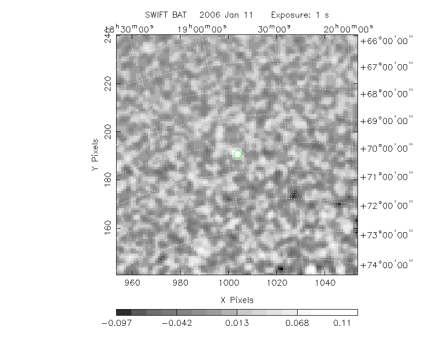
The green circle (6 arcmin radius) is the BAT position (RA, Dec) = (286.337, +70.360).
Search BAT source with the INTEGRAL catalog
known_source_INTEGRAL.sh 286.337 +70.360 1.0
4U1859+69       ( 284.750 ,  69.700 )     delta= 0.854
Results of batcelldetect
Search for the BAT bright source catalog
DPI of the combined detector enable/disable map (archived enable/disable map + downloaded data)

DPI of the scaled map

Pixel vs. Counts plot

The data/results are in /local/data/raid2/prebascript/trigger176918/tdrss_ql/

bat_scaledmap.fits : TDRSS FITS scaled map from GCN
source.img         : Sky FITS image of the scaled map (batfftimage)
source.list        : FITS list of the detected sources (batcelldetect)
scaledmap.log      : Ascii output of the analysis log
bat_pos.reg        : region file for ds9
source.gif         : GIF sky image

Processed time:
Wed Jan 11 15:26:37 EST 2006