TDRSS scaled map for 303609
GCN BAT Position Notice
TITLE:           GCN/SWIFT NOTICE
NOTICE_DATE:     Mon 18 Feb 08 20:09:21 UT
NOTICE_TYPE:     Swift-BAT GRB Position
TRIGGER_NUM:     303609,   Seg_Num: 0
GRB_RA:          355.922d {+23h 43m 41s} (J2000),
                 356.025d {+23h 44m 06s} (current),
                 355.286d {+23h 41m 09s} (1950)
GRB_DEC:         +12.175d {+12d 10' 29"} (J2000),
                 +12.220d {+12d 13' 12"} (current),
                 +11.897d {+11d 53' 50"} (1950)
GRB_ERROR:       3.00 [arcmin radius, statistical only]
GRB_INTEN:       15663 [cnts]    Image_Peak=224 [image_cnts]
TRIGGER_DUR:     4.096 [sec]
TRIGGER_INDEX:   291     E_range: 15-50 keV
BKG_INTEN:       143465 [cnts]
BKG_TIME:        72469.41 SOD {20:07:49.41} UT
BKG_DUR:         40 [sec]
GRB_DATE:        14514 TJD;    49 DOY;   08/02/18
GRB_TIME:        72522.79 SOD {20:08:42.79} UT
GRB_PHI:         -36.12 [deg]
GRB_THETA:        47.40 [deg]
SOLN_STATUS:     0x83
RATE_SIGNIF:     9.84 [sigma]
IMAGE_SIGNIF:    6.62 [sigma]
MERIT_PARAMS:     +1  +0  +0  +2  +1  +0 -100  +0 -83  +1
SUN_POSTN:       331.65d {+22h 06m 37s}  -11.63d {-11d 37' 51"}
SUN_DIST:         33.97 [deg]   Sun_angle= -1.6 [hr] (East of Sun)
MOON_POSTN:      123.53d {+08h 14m 07s}  +22.24d {+22d 14' 19"}
MOON_DIST:       118.08 [deg]
MOON_ILLUM:      94 [%]
GAL_COORDS:       98.05,-47.40 [deg] galactic lon,lat of the burst (or transient)
ECL_COORDS:        1.18, 12.78 [deg] ecliptic lon,lat of the burst (or transient)
COMMENTS:        SWIFT-BAT GRB Coordinates.
COMMENTS:        This is a rate trigger.
COMMENTS:        A point_source was found.
COMMENTS:        This does not match any source in the on-board catalog.
COMMENTS:        This does not match any source in the ground catalog.
COMMENTS:        This is a GRB.
COMMENTS:        Since the IMAGE_SIGNIF is less than 7 sigma, this is a questionable detection.
COMMENTS:        This trigger occurred at longitude,latitude = 278.21,20.27 [deg].
GCN BAT Scaled Map Notice
TITLE:           GCN/SWIFT NOTICE
NOTICE_DATE:     Mon 18 Feb 08 20:17:28 UT
NOTICE_TYPE:     Swift-BAT Scaled Map
TRIGGER_NUM:     303609,   Seg_Num: 0
POINT_RA:         28.064d {+01h 52m 15s} (J2000)
POINT_DEC:       -23.306d {-23d 18' 21"} (J2000)
MAP_DATE:        14514 TJD;    49 DOY;   08/02/18
MAP_TIME:        72522.79 SOD {20:08:42.79} UT
TRIGGER_DUR:     4.096 [sec]
SOLN_STATUS:     0x83
RATE_SIGNIF:     9.84 [sigma]
IMAGE_SIGNIF:    6.62 [sigma]
MAP_URL:         sw00303609000msbsm.fits
SUN_POSTN:       331.66d {+22h 06m 38s}  -11.63d {-11d 37' 44"}
MOON_POSTN:      123.61d {+08h 14m 27s}  +22.22d {+22d 12' 55"}
MOON_ILLUM:      94 [%]
GAL_COORDS:      200.75,-75.73 [deg] galactic lon,lat of the pointing direction
ECL_COORDS:       16.43,-32.33 [deg] ecliptic lon,lat of the pointing direction
COMMENTS:        SWIFT-BAT Scaled Map.
COMMENTS:
COMMENTS:        The next comments were copied from the BAT_POS Notice:
Scaled map image
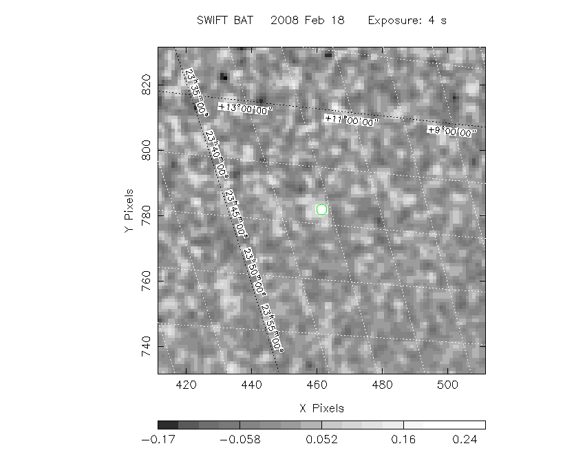
The green circle (6 arcmin radius) is the BAT position (RA, Dec) = (355.922, +12.175).
Search BAT source with the INTEGRAL catalog
known_source_INTEGRAL.sh 355.922 +12.175 1.0
No source found
Results of batcelldetect
# RAcent  DECcent POSerr Theta    Phi  PeakCts   SNR AngSep     Name
#  [deg]    [deg]    ['] [deg]  [deg]                   [']
 19.2787 -73.4424  312.4  50.4 -167.9  -0.0014  -0.0    0.1	SMC X-1
 83.1213 -66.4728   15.9  55.1  165.3  -0.0672  -0.7    6.5	LMC X-4
 50.1114  -7.5869    2.8  26.4   65.8   0.1281   4.2 ------	UNKNOWN
 54.8368 -27.6962    2.5  24.5  114.8   0.1423   4.6 ------	UNKNOWN
 43.8617   2.3738    2.4  29.9   41.9   0.1314   4.9 ------	UNKNOWN
 56.3822 -39.5857    2.4  28.9  139.7   0.1360   4.8 ------	UNKNOWN
 38.3217  11.1443    2.5  35.9   26.2   0.1112   4.7 ------	UNKNOWN
 50.2998 -56.8679    2.7  37.3  168.8   0.1278   4.3 ------	UNKNOWN
 33.4853 -67.2347    2.7  44.1 -174.2   0.1332   4.2 ------	UNKNOWN
 12.0066 -59.1081    2.7  37.6 -157.7   0.0851   4.3 ------	UNKNOWN
  6.8679  13.4738    2.4  42.2  -22.7   0.1228   4.8 ------	UNKNOWN
355.9345  12.1959    1.9  47.4  -36.1   0.2544   6.3 ------	UNKNOWN
345.3635  -1.8451    2.5  46.6  -60.1   0.5748   4.6 ------	UNKNOWN
Search for the BAT bright source catalog
# RAcent  DECcent POSerr Theta    Phi  PeakCts   SNR AngSep     Name
#  [deg]    [deg]    ['] [deg]  [deg]                   [']
 50.1114  -7.5869    2.8  26.4   65.8   0.1281   4.2 ------	UNKNOWN
 54.8368 -27.6962    2.5  24.5  114.8   0.1423   4.6 ------	UNKNOWN
 43.8617   2.3738    2.4  29.9   41.9   0.1314   4.9 ------	UNKNOWN
 56.3822 -39.5857    2.4  28.9  139.7   0.1360   4.8 ------	UNKNOWN
 38.3217  11.1443    2.5  35.9   26.2   0.1112   4.7 ------	UNKNOWN
 50.2998 -56.8679    2.7  37.3  168.8   0.1278   4.3 ------	UNKNOWN
 33.4853 -67.2347    2.7  44.1 -174.2   0.1332   4.2 ------	UNKNOWN
 12.0066 -59.1081    2.7  37.6 -157.7   0.0851   4.3 ------	UNKNOWN
  6.8679  13.4738    2.4  42.2  -22.7   0.1228   4.8 ------	UNKNOWN
355.9345  12.1959    1.9  47.4  -36.1   0.2544   6.3 ------	UNKNOWN
345.3635  -1.8451    2.5  46.6  -60.1   0.5748   4.6 ------	UNKNOWN

Search for UNKNOWN source R.A. = 6.8679 Dec. = +13.4738 (search radius of 3 degrees)
No bright source found.

Search for UNKNOWN source R.A. = 12.0066 Dec. = -59.1081 (search radius of 3 degrees)
No bright source found.

Search for UNKNOWN source R.A. = 33.4853 Dec. = -67.2347 (search radius of 3 degrees)
No bright source found.

Search for UNKNOWN source R.A. = 38.3217 Dec. = +11.1443 (search radius of 3 degrees)
No bright source found.

Search for UNKNOWN source R.A. = 43.8617 Dec. = +2.3738 (search radius of 3 degrees)
No bright source found.

Search for UNKNOWN source R.A. = 50.1114 Dec. = -7.5869 (search radius of 3 degrees)
No bright source found.

Search for UNKNOWN source R.A. = 50.2998 Dec. = -56.8679 (search radius of 3 degrees)
No bright source found.

Search for UNKNOWN source R.A. = 54.8368 Dec. = -27.6962 (search radius of 3 degrees)
No bright source found.

Search for UNKNOWN source R.A. = 56.3822 Dec. = -39.5857 (search radius of 3 degrees)
No bright source found.

Search for UNKNOWN source R.A. = 345.3635 Dec. = -1.8451 (search radius of 3 degrees)
No bright source found.

Search for UNKNOWN source R.A. = 355.9345 Dec. = +12.1959 (search radius of 3 degrees)
No bright source found.
DPI of the combined detector enable/disable map (archived enable/disable map + downloaded data)

DPI of the scaled map

Pixel vs. Counts plot

The data/results are in /local/data/raid2/prebascript/trigger303609/tdrss_ql/

bat_scaledmap.fits : TDRSS FITS scaled map from GCN
source.img         : Sky FITS image of the scaled map (batfftimage)
source.list        : FITS list of the detected sources (batcelldetect)
scaledmap.log      : Ascii output of the analysis log
bat_pos.reg        : region file for ds9
source.gif         : GIF sky image

Processed time:
Mon Feb 18 15:20:25 EST 2008