TDRSS scaled map for 357512
GCN BAT Position Notice
TITLE:           GCN/SWIFT NOTICE
NOTICE_DATE:     Wed 15 Jul 09 21:10:59 UT
NOTICE_TYPE:     Swift-BAT GRB Position
TRIGGER_NUM:     357512,   Seg_Num: 0
GRB_RA:          251.344d {+16h 45m 23s} (J2000),
                 251.416d {+16h 45m 40s} (current),
                 250.966d {+16h 43m 52s} (1950)
GRB_DEC:         +44.827d {+44d 49' 36"} (J2000),
                 +44.810d {+44d 48' 35"} (current),
                 +44.917d {+44d 54' 60"} (1950)
GRB_ERROR:       3.00 [arcmin radius, statistical only]
GRB_INTEN:       5636 [cnts]    Image_Peak=332 [image_cnts]
TRIGGER_DUR:     1.024 [sec]
TRIGGER_INDEX:   146     E_range: 25-100 keV
BKG_INTEN:       30987 [cnts]
BKG_TIME:        75779.08 SOD {21:02:59.08} UT
BKG_DUR:         8 [sec]
GRB_DATE:        15027 TJD;   196 DOY;   09/07/15
GRB_TIME:        75794.63 SOD {21:03:14.63} UT
GRB_PHI:         -66.34 [deg]
GRB_THETA:         5.29 [deg]
SOLN_STATUS:     0x3
RATE_SIGNIF:     24.95 [sigma]
IMAGE_SIGNIF:    11.48 [sigma]
MERIT_PARAMS:     +1  +0  +0  +0  +2  +1  +0  +0 +21  +0
SUN_POSTN:       115.35d {+07h 41m 25s}  +21.39d {+21d 23' 36"}
SUN_DIST:        102.63 [deg]   Sun_angle= -9.1 [hr] (East of Sun)
MOON_POSTN:       25.09d {+01h 40m 22s}  +16.12d {+16d 07' 15"}
MOON_DIST:       105.96 [deg]
MOON_ILLUM:      45 [%]
GAL_COORDS:       70.10, 40.65 [deg] galactic lon,lat of the burst (or transient)
ECL_COORDS:      235.98, 66.08 [deg] ecliptic lon,lat of the burst (or transient)
COMMENTS:        SWIFT-BAT GRB Coordinates.
COMMENTS:        This Notice was delayed by more than 60 sec past the end of the trigger integration interval;
COMMENTS:        probably due to it occurring during a Malindi downlink session.
COMMENTS:        This is a rate trigger.
COMMENTS:        A point_source was found.
COMMENTS:        This does not match any source in the on-board catalog.
COMMENTS:        This does not match any source in the ground catalog.
COMMENTS:        This is a GRB.
COMMENTS:        This trigger occurred at longitude,latitude = 18.96,-20.43 [deg].
GCN BAT Scaled Map Notice
TITLE:           GCN/SWIFT NOTICE
NOTICE_DATE:     Wed 15 Jul 09 21:17:13 UT
NOTICE_TYPE:     Swift-BAT Scaled Map
TRIGGER_NUM:     357512,   Seg_Num: 0
POINT_RA:        253.451d {+16h 53m 48s} (J2000)
POINT_DEC:       +39.765d {+39d 45' 53"} (J2000)
MAP_DATE:        15027 TJD;   196 DOY;   09/07/15
MAP_TIME:        75794.63 SOD {21:03:14.63} UT
TRIGGER_DUR:     1.024 [sec]
SOLN_STATUS:     0x3
RATE_SIGNIF:     24.95 [sigma]
IMAGE_SIGNIF:    11.48 [sigma]
MAP_URL:         sw00357512000msbsm.fits
SUN_POSTN:       115.36d {+07h 41m 26s}  +21.39d {+21d 23' 34"}
MOON_POSTN:       25.15d {+01h 40m 36s}  +16.14d {+16d 08' 29"}
MOON_ILLUM:      45 [%]
GAL_COORDS:       63.60, 38.87 [deg] galactic lon,lat of the pointing direction
ECL_COORDS:      242.56, 61.64 [deg] ecliptic lon,lat of the pointing direction
COMMENTS:        SWIFT-BAT Scaled Map.
COMMENTS:
COMMENTS:        WARNING: No BAT_Position TDRSS message was received for this trigger_number!
Scaled map image
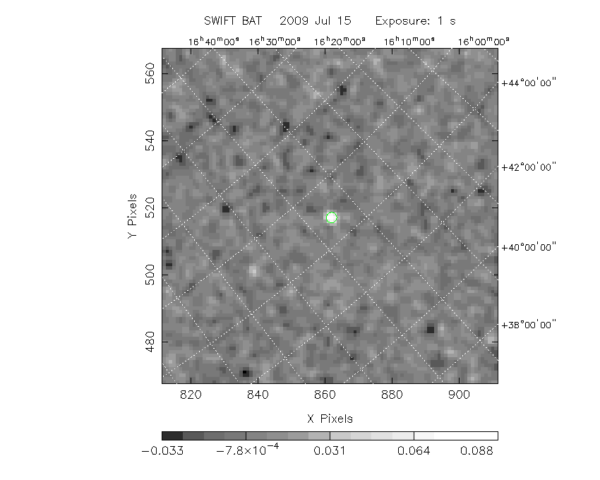
The green circle (6 arcmin radius) is the BAT position (RA, Dec) = (251.344, +44.827).
Search BAT source with the INTEGRAL catalog
known_source_INTEGRAL.sh 251.344 +44.827 1.0
No source found
Results of batcelldetect
# RAcent  DECcent POSerr Theta    Phi  PeakCts   SNR AngSep     Name
#  [deg]    [deg]    ['] [deg]  [deg]                   [']
213.3665  -3.2736    5.1  56.6 -179.5   0.1106   2.3    5.1
254.5181  35.1890    7.9   4.7  119.5   0.0132   1.4    9.7
278.9780  32.6298    7.4  21.7   51.4   0.0162   1.6   11.8
288.8766  10.9001    3.9  42.6   73.0  -0.2051  -3.0    5.4
297.3961  30.0699    4.2  36.9   41.5   0.0462   2.8    8.3
298.7682  32.0653    7.1  37.1   37.6   0.0256   1.6    8.4
299.4145  35.2088    4.9  36.3   32.4  -0.0361  -2.4    8.6
299.6951  40.5707    0.0  34.9   23.5  -0.0208  -1.6   12.6
308.1918  37.5431    5.8  42.1   25.0   0.0371   2.0    8.3
308.1355  40.8487   20.5  41.0   20.3   0.0090   0.6    6.3
314.6500  41.7012    4.3  45.4   16.9  -0.0520  -2.7    5.0
321.0519  51.0898    6.1  47.0    2.7   0.0361   1.9    8.1
323.4815  51.1704    5.4  48.5    2.1  -0.0438  -2.1    3.4
326.2344  38.3337    7.8  54.9   16.5   0.0896   1.5    3.0
332.1906  54.4186    7.2  52.6   -3.9   0.0396   1.6    9.5
251.3581  44.8216    1.0   5.3  -66.3   0.1000  11.5 ------
306.4893  63.4038    2.1  38.8  -15.1   0.0660   5.5 ------
297.4492  72.7456    2.1  39.2  -30.8   0.0750   5.5 ------
Search for the BAT bright source catalog
# RAcent  DECcent POSerr Theta    Phi  PeakCts   SNR AngSep     Name
#  [deg]    [deg]    ['] [deg]  [deg]                   [']
254.5181  35.1890    7.9   4.7  119.5   0.0132   1.4    9.7
288.8765  10.9000    3.9  42.6   73.0  -0.2050  -3.0    5.4
299.4145  35.2088    4.9  36.3   32.4  -0.0361  -2.4    8.6
308.1356  40.8485   20.5  41.0   20.3   0.0090   0.6    6.3
326.2344  38.3337    7.8  54.9   16.5   0.0896   1.5    3.0
251.3581  44.8216    1.0   5.3  -66.3   0.1000  11.5 ------
306.4893  63.4038    2.1  38.8  -15.1   0.0660   5.5 ------
297.4492  72.7456    2.1  39.2  -30.8   0.0750   5.5 ------

Search for UNKNOWN source R.A. = 251.3581 Dec. = +44.8216 (search radius of 3 degrees)
No bright source found.

Search for UNKNOWN source R.A. = 297.4492 Dec. = +72.7456 (search radius of 3 degrees)
No bright source found.

Search for UNKNOWN source R.A. = 306.4892 Dec. = +63.4038 (search radius of 3 degrees)
No bright source found.
DPI of the combined detector enable/disable map (archived enable/disable map + downloaded data)

DPI of the scaled map

Pixel vs. Counts plot

The data/results are in /local/data/raid2/prebascript/trigger357512/tdrss_ql/

bat_scaledmap.fits : TDRSS FITS scaled map from GCN
source.img         : Sky FITS image of the scaled map (batfftimage)
source.list        : FITS list of the detected sources (batcelldetect)
scaledmap.log      : Ascii output of the analysis log
bat_pos.reg        : region file for ds9
source.gif         : GIF sky image

Processed time:
Wed Jul 15 17:19:03 EDT 2009