TDRSS scaled map for 444912
GCN BAT Position Notice
TITLE:           GCN/SWIFT NOTICE
NOTICE_DATE:     Mon 07 Feb 11 11:17:34 UT
NOTICE_TYPE:     Swift-BAT GRB Position
TRIGGER_NUM:     444912,   Seg_Num: 0
GRB_RA:           12.542d {+00h 50m 10s} (J2000),
                  12.682d {+00h 50m 44s} (current),
                  11.913d {+00h 47m 39s} (1950)
GRB_DEC:         -10.806d {-10d 48' 20"} (J2000),
                 -10.745d {-10d 44' 42"} (current),
                 -11.078d {-11d 04' 39"} (1950)
GRB_ERROR:       3.00 [arcmin radius, statistical only]
GRB_INTEN:       557 [cnts]    Image_Peak=62 [image_cnts]
TRIGGER_DUR:     0.064 [sec]
TRIGGER_INDEX:   10418     E_range: 25-100 keV
BKG_INTEN:       35752 [cnts]
BKG_TIME:        40625.35 SOD {11:17:05.35} UT
BKG_DUR:         8 [sec]
GRB_DATE:        15599 TJD;    38 DOY;   11/02/07
GRB_TIME:        40639.75 SOD {11:17:19.75} UT
GRB_PHI:         -35.00 [deg]
GRB_THETA:        14.37 [deg]
SOLN_STATUS:     0x2003
RATE_SIGNIF:     15.58 [sigma]
IMAGE_SIGNIF:    7.39 [sigma]
MERIT_PARAMS:     +1  +0  +0  -4  +2  -3  -5  +0 -63  +0
SUN_POSTN:       320.76d {+21h 23m 02s}  -15.34d {-15d 20' 07"}
SUN_DIST:         50.68 [deg]   Sun_angle= -3.5 [hr] (East of Sun)
MOON_POSTN:        3.65d {+00h 14m 35s}   +7.15d {+07d 08' 57"}
MOON_DIST:        20.03 [deg]
MOON_ILLUM:      16 [%]
GAL_COORDS:      121.82,-73.67 [deg] galactic lon,lat of the burst (or transient)
ECL_COORDS:        7.20,-14.88 [deg] ecliptic lon,lat of the burst (or transient)
COMMENTS:        SWIFT-BAT GRB Coordinates.
COMMENTS:        This is a rate trigger.
COMMENTS:        A point_source was found.
COMMENTS:        This does not match any source in the on-board catalog.
COMMENTS:        This does not match any source in the ground catalog.
COMMENTS:        There is a bright star (mag=5.19) 9.70 arcmin from this position.
COMMENTS:        This is a GRB.
COMMENTS:        This trigger occurred at longitude,latitude = 48.37,-13.78 [deg].
GCN BAT Scaled Map Notice
TITLE:           GCN/SWIFT NOTICE
NOTICE_DATE:     Mon 07 Feb 11 11:26:18 UT
NOTICE_TYPE:     Swift-BAT Scaled Map
TRIGGER_NUM:     444912,   Seg_Num: 0
POINT_RA:         23.881d {+01h 35m 31s} (J2000)
POINT_DEC:       -20.187d {-20d 11' 11"} (J2000)
MAP_DATE:        15599 TJD;    38 DOY;   11/02/07
MAP_TIME:        40640.01 SOD {11:17:20.01} UT
TRIGGER_DUR:     0.064 [sec]
SOLN_STATUS:     0x2003
RATE_SIGNIF:     15.58 [sigma]
IMAGE_SIGNIF:    7.39 [sigma]
MAP_URL:         sw00444912000msbsm.fits
SUN_POSTN:       320.77d {+21h 23m 04s}  -15.33d {-15d 20' 00"}
MOON_POSTN:        3.71d {+00h 14m 51s}   +7.18d {+07d 10' 38"}
MOON_ILLUM:      17 [%]
GAL_COORDS:      180.74,-77.76 [deg] galactic lon,lat of the pointing direction
ECL_COORDS:       13.83,-27.89 [deg] ecliptic lon,lat of the pointing direction
COMMENTS:        SWIFT-BAT Scaled Map.
COMMENTS:
COMMENTS:        The next comments were copied from the BAT_POS Notice:
Scaled map image
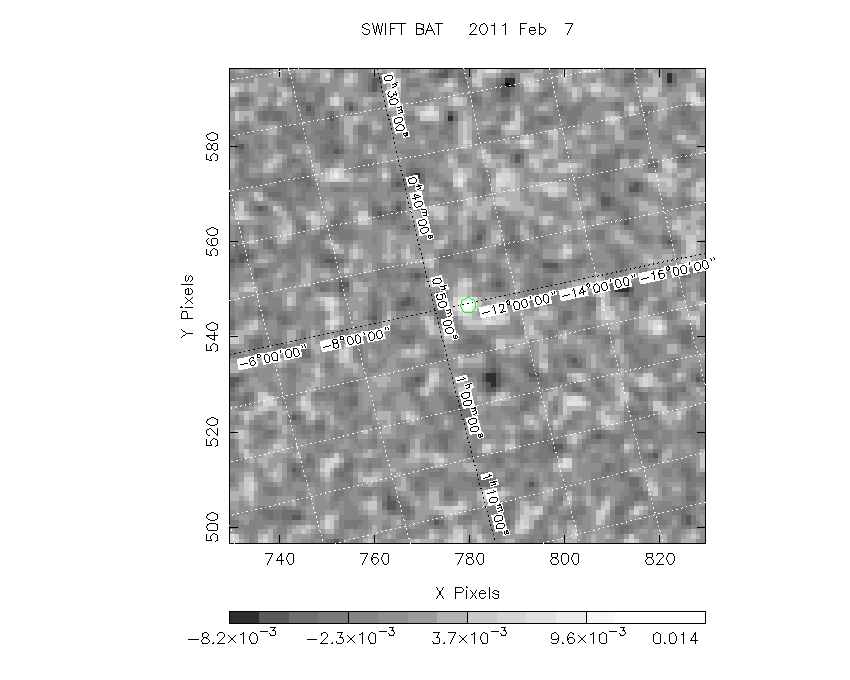
The green circle (6 arcmin radius) is the BAT position (RA, Dec) = (12.542, -10.806).
Search BAT source with the INTEGRAL catalog
known_source_INTEGRAL.sh 12.542 -10.806 1.0
No source found
Results of batcelldetect
# RAcent  DECcent POSerr Theta    Phi  PeakCts   SNR AngSep     Name
#  [deg]    [deg]    ['] [deg]  [deg]                   [']
 19.2729 -73.4422    0.0  53.3 -162.3  -0.0080  -1.1    0.0	SMC X-1
343.4906  16.1482    0.0  53.8  -34.5  -0.0032  -0.2    0.0	3C 454.3
 34.3322  -2.9306    2.1  20.0   48.0   0.0148   5.6 ------	UNKNOWN
 12.5317 -10.7649    1.9  14.4  -34.9   0.0143   6.0 ------	UNKNOWN
 12.5293 -76.2719    2.7  56.4 -160.8   0.0376   4.3 ------	UNKNOWN
Search for the BAT bright source catalog
# RAcent  DECcent POSerr Theta    Phi  PeakCts   SNR AngSep     Name
#  [deg]    [deg]    ['] [deg]  [deg]                   [']
 34.3322  -2.9306    2.1  20.0   48.0   0.0148   5.6 ------	UNKNOWN
 12.5317 -10.7649    1.9  14.4  -34.9   0.0143   6.0 ------	UNKNOWN
 12.5293 -76.2719    2.7  56.4 -160.8   0.0376   4.3 ------	UNKNOWN

Search for UNKNOWN source R.A. = 12.5293 Dec. = -76.2719 (search radius of 3 degrees)
No bright source found.

Search for UNKNOWN source R.A. = 12.5317 Dec. = -10.7649 (search radius of 3 degrees)
No bright source found.

Search for UNKNOWN source R.A. = 34.3322 Dec. = -2.9306 (search radius of 3 degrees)
No bright source found.
DPI of the combined detector enable/disable map (archived enable/disable map + downloaded data)

DPI of the scaled map

Pixel vs. Counts plot

The data/results are in /local/data/raid2/prebascript/trigger444912/tdrss_ql/

bat_scaledmap.fits : TDRSS FITS scaled map from GCN
source.img         : Sky FITS image of the scaled map (batfftimage)
source.list        : FITS list of the detected sources (batcelldetect)
scaledmap.log      : Ascii output of the analysis log
bat_pos.reg        : region file for ds9
source.gif         : GIF sky image

Processed time:
Mon Feb  7 06:27:53 EST 2011